Bahnhofstraße (Porz): Unterschied zwischen den Versionen
Aus KoelnWiki
K (Link angepasst) |
(Infobox hinzugefügt) |
||
| Zeile 1: | Zeile 1: | ||
| − | {{ | + | {{Infobox Straße |
| − | + | | lat = 50.883863 | |
| + | | lon = 7.056633 | ||
| + | | z = | ||
| + | | bild = bahnhofstrasse_porz.jpg | ||
| + | | plz1 = 51143 | ||
| + | | plz2 = | ||
| + | | plz3 = | ||
| + | | plz4 = | ||
| + | | plz5 = | ||
| + | | stadtteil1 = Porz | ||
| + | | stadtteil2 = | ||
| + | | stadtteil3 = | ||
| + | | stadtteil4 = | ||
| + | | stadtteil5 = | ||
| + | | von = Friedrich-Ebert-Ufer | ||
| + | | bis = Haltestelle Bf Porz | ||
| + | | laenge = | ||
| + | | nummer = | ||
| + | }} | ||
Die '''Bahnhofstraße''' ist eine Straße in [[Porz]]. | Die '''Bahnhofstraße''' ist eine Straße in [[Porz]]. | ||
| Zeile 10: | Zeile 28: | ||
{{nächste Haltestelle|Porz Markt}} | {{nächste Haltestelle|Porz Markt}} | ||
| − | |||
[[Kategorie:Straße B]] | [[Kategorie:Straße B]] | ||
Version vom 5. November 2016, 10:50 Uhr
| Bild | ||
|---|---|---|

| ||
| Lage | ||
| ||
| Informationen | ||
| Straßennummer: | unbekannt | |
| PLZ: | 51143 | |
| Stadtteil: | Porz | |
| von: | Friedrich-Ebert-Ufer | |
| bis: | Haltestelle Bf Porz | |
| Länge: | unbekannt | |
| Stand | ||
| 5.11.2016 | ||
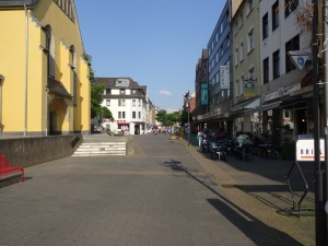
Die Bahnhofstraße ist eine Straße in Porz.
Lage
Verlauf
Die Bahnhofstraße verläuft vom Friedrich-Ebert-Ufer bis zur Haltestelle Bf Porz. Das Teilstück von der Hauptstraße bis zur Mühlenstraße ist dabei eine Fußgängerzone ("Porzity").
ÖPNV
| |